| 1 |
SCURLOCK J M O, HALL D O.The global carbon sink:a grassland perspective[J].Global Change Biology,1998, 4(2):229-233.
|
| 2 |
HOWARTH R B, FARBER S.Accounting for the value of ecosystem services[J].Ecological Economics,2002,41(3):421-429.
|
| 3 |
CHEE Y E.An ecological perspective on the valuation of ecosystem services[J].Biological Conservation,2004, 120(4):549-565.
|
| 4 |
臧淑英,那晓东,冯仲科.基于植被指数的大庆地区草地退化因子遥感定量反演模型的研制[J].北京林业大学学报,2008,30():98-104.
|
|
ZANG S Y, NA X D, FENG Z K.Establishment of quantitative remote sensing inversion model of grassland degradation factors based on vegetation indices in Daqing city,northeastern China[J].Journal of Beijing Forestry University,2008,30(Sup.1):98-104.
|
| 5 |
MAO D H, WANG Z M, LI L,et al.Spatiotemporal dynamics of grassland aboveground net primary productivity and its association with climatic pattern and changes in Northern China[J].Ecological Indicators,2014,41:40-48.
|
| 6 |
SALOMONSON V V, APPEL I.Estimating fractional snow cover from MODIS using the normalized difference snow index[J].Remote Sensing of Environment,2004,89(3):351-360.
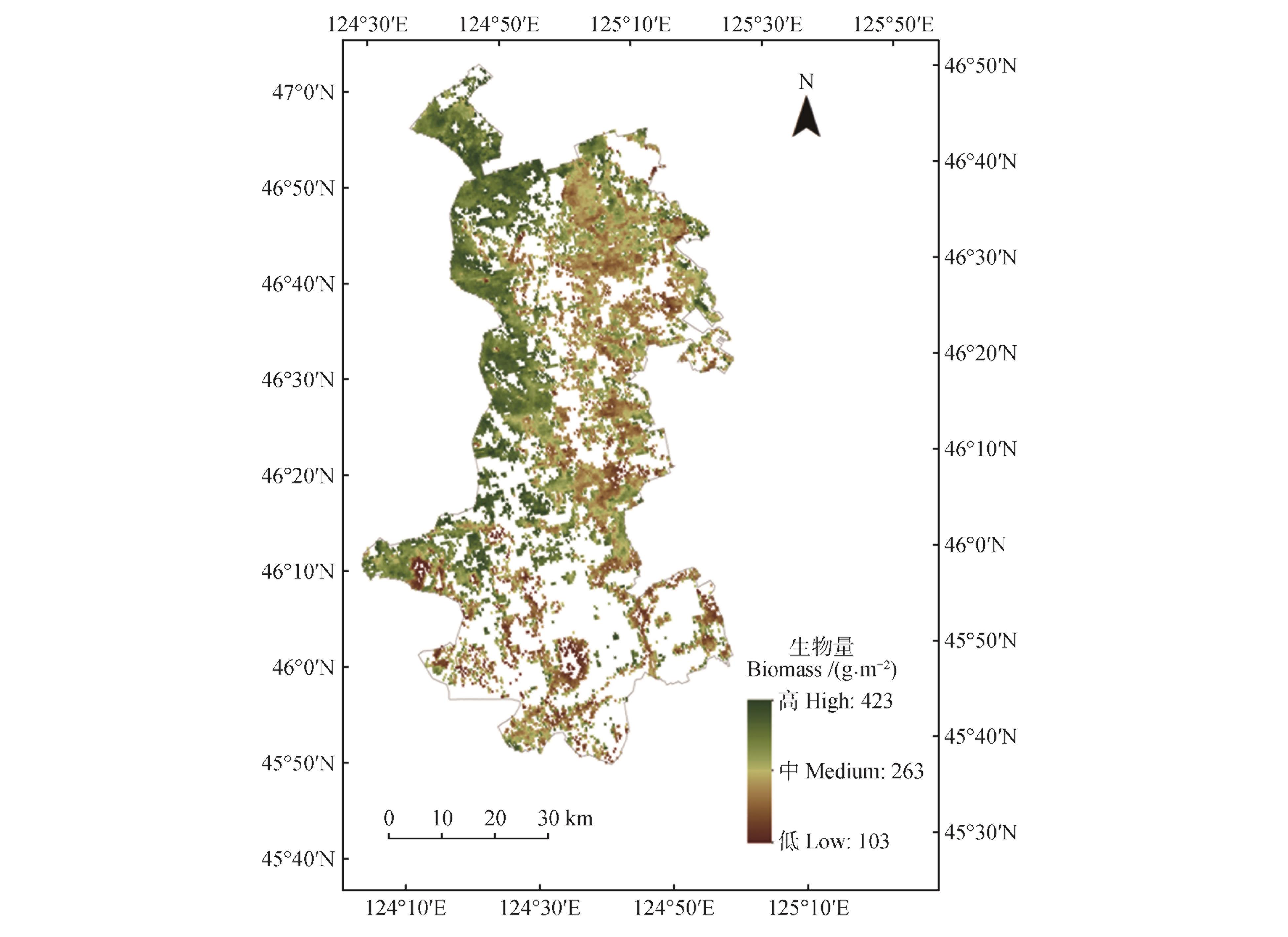
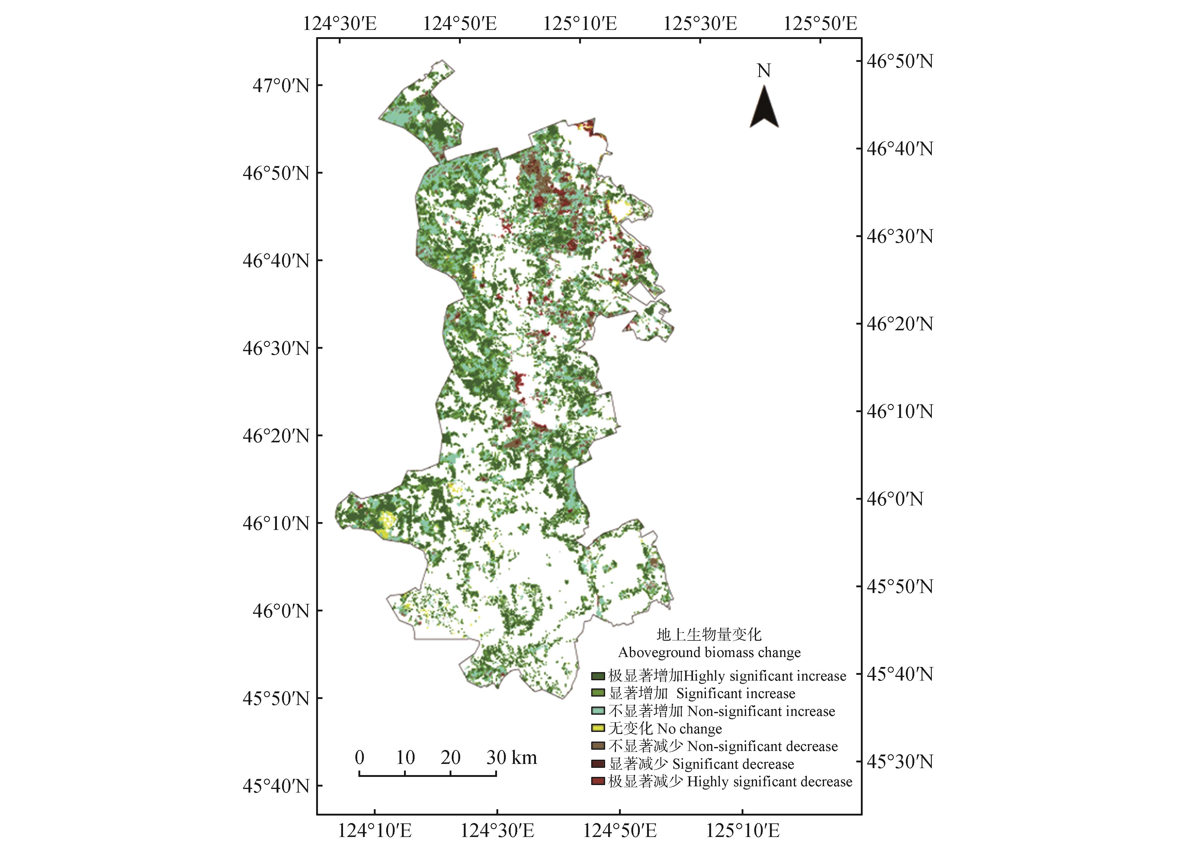
|
| 7 |
WRIGHT R, FLYNN L, GARBEIL H,et al.Automated volcanic eruption detection using MODIS[J].Remote Sensing of Environment,2002,82(1):135-155.
|
| 8 |
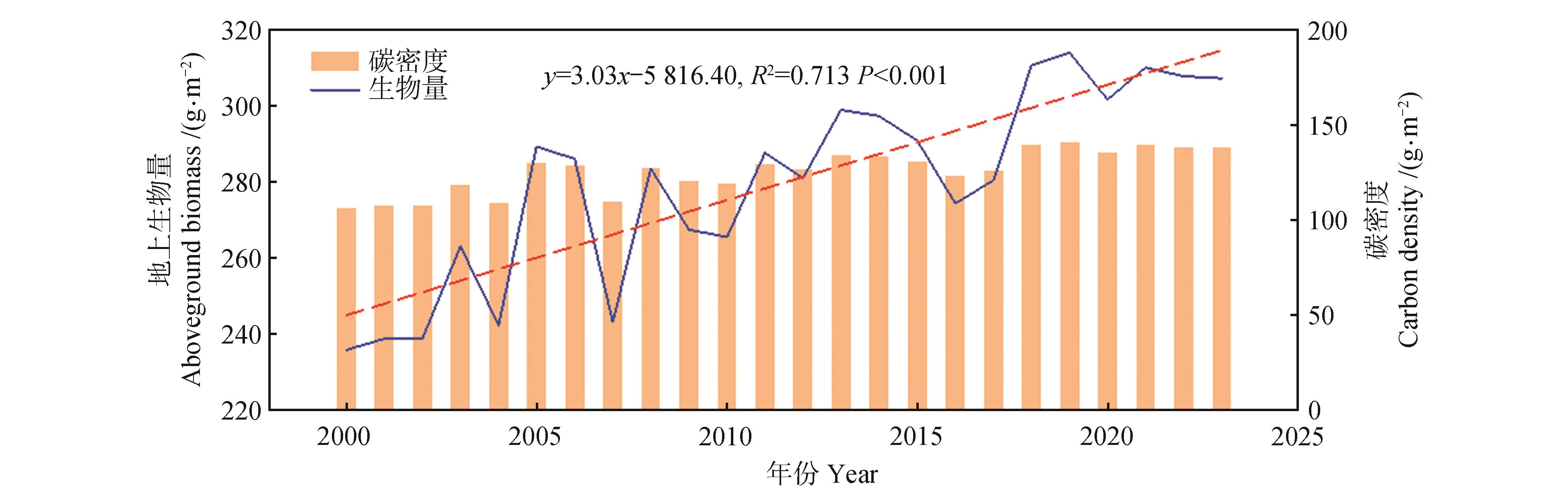
ZHAN X, SOHLBERG R A, TOWNSHEND J R G,et al.Detection of land cover changes using MODIS 250 m data[J].Remote Sensing of Environment,2002,83(1/2):336-350.
|
| 9 |
DE LA IGLESIA MARTINEZ A, LABIB S M.Demystifying normalized difference vegetation index (NDVI) for greenness exposure assessments and policy interventions in urban greening[J].Environmental Research,2023,220:115155.
|
| 10 |
USMAN M, LIEDL R, SHAHID M A,et al.Land use/land cover classification and its change detection using multi-temporal MODIS NDVI data[J].Journal of Geographical Sciences,2015,25:1479-1506.
|
| 11 |
LAI L, ZHANG Y C, HAN T,et al.Satellite mapping reveals phytoplankton biomass’s spatio-temporal dynamics and responses to environmental factors in a eutrophic inland lake[J].Journal of Environmental Management,2024,360:121134.
|
| 12 |
GE J, HOU M J, LIANG T G,et al.Spatiotemporal dynamics of grassland aboveground biomass and its driving factors in North China over the past 20 years[J].Science of the Total Environment,2022,826:154226.
|
| 13 |
王公鑫,井长青,董萍,等.新疆荒漠草地生物量估算及影响因素研究[J].草地学报,2022,30(7):1862-1872.
|
|
WANG G X, JING C Q, DONG P,et al.Study on biomass estimation and influencing factors of desert grassland in Xinjiang[J].Acta Agrestia Sinica,2022,30(7):1862-1872.
|
| 14 |
韩波,高艳妮,郭杨,等.三江源区高寒草地地上生物量遥感反演模型研究[J].环境科学研究,2017, 30(1):67-74.
|
|
HAN B, GAO Y N, GUO Y,et al.Modeling aboveground biomass of alpine grassland in the Three-River Headwaters Region based on remote sensing data[J].Research of Environmental Sciences,2017,30(1):67-74.
|
| 15 |
赵慧芳,李晓东,张东,等.基于MODIS数据的青海省草地地上生物量估算及影响因素研究[J].草业学报,2020,29(12):5-16.
|
|
ZHAO H F, LI X D, ZHANG D,et al.Aboveground biomass in grasslands in Qinghai Province estimated from MODIS data and its influencing factors[J].Acta Prataculturae Sinica,2020,29(12):5-16.
|
| 16 |
SHAO Q Q, LIU J Y, HUANG L,et al.Integrated assessment on the effectiveness of ecological conservation in Sanjiangyuan National Nature Reserve[J].Geographical Research,2013,32(9):1645-1656.
|
| 17 |
WU Z, DAI E F, WU Z F,et al.Assessing differences in the response of forest aboveground biomass and composition under climate change in subtropical forest transition zone[J].Science of the Total Environment,2020,706:135746.
|
| 18 |
LI S, DONG S K, FU Y S,et al.Air or soil temperature matters the responses of alpine plants in biomass accumulation to climate warming[J].Science of the Total Environment,2022,844:157141.
|
| 19 |
PANG B, LIU K, JIA W.Discussion on geomorphic features and division of Songhua River Basin[J].Geographical Science Research,2021,10(3):290-294.
|
| 20 |
邢海超,杨智明.大庆市草地数量特征空间分布研究[J].中国草地学报,2017,39(1):117-120.
|
|
XING H C, YANG Z M.Study on the spatial distribution of quantity feature of grassland in Daqing[J].Chinese Journal of Grassland,2017,39(1):117-120.
|
| 21 |
夏志明,廖凯涛,郭利平,等.基于EOF和MK趋势分析的赣江流域降水时空分布格局[J].水土保持研究,2023,30(5):223-233.
|
|
XIA Z M, LIAO K T, GUO L P,et al.Spatiotemporal distribution pattern of precipitation in Ganjiang River Basin based on EOF and MK trend analysis[J].Research of Soil and Water Conservation,2023,30(5):223-233.
|
| 22 |
JIANG W G, YUAN L H, WANG W J,et al.Spatio-temporal analysis of vegetation variation in the Yellow River Basin[J].Ecological Indicators,2015,51:117-126.
|
| 23 |
方精云,郭兆迪,朴世龙,等.1981—2000年中国陆地植被碳汇的估算[J].中国科学:D辑 地球科学,2007,37(6):804-812.
|
|
FANG J Y, GUO Z D, PIAO S L,et al.Terrestrial vegetation carbon sinks in China,1981—2000[J].Science in China Series D:Earth Sciences,2007,37(6):804-812.
|
| 24 |
徐丽,何念鹏,于贵瑞.2010s中国陆地生态系统碳密度数据集[J].中国科学数据(中英文网络版),2019, 4(1):90-96.
|
|
XU L, HE N P, YU G R.A dataset of carbon density in Chinese terrestrial ecosystems(2010s)[J].China Scientific Data,2019,4(1):90-96.
|
| 25 |
车占杉.大庆市天然草地地上部分生物量季节动态观测[J].中国畜牧杂志,1998,34(6):32-33.
|
|
CHE Z S.Seasonal dynamics of aboveground biomass of natural grassland in Daqing[J].Chinese Journal of Animal Science,1998,34(6):32-33.
|
| 26 |
孙杰,贺箐蕾,付佳琦,等.松嫩平原不同类型天然草地植物群落特征研究[C]//中国草学会.中国草学会第九次全国会员代表大会暨学术讨论会论文集.哈尔滨:东北农业大学动物科学技术学院,2016:9.
|
|
SUN J, HE Y L, FU J Q,et al.Study on the characteristics of plant communities in different types of grassland in the Songnen Plain[C]//Chinese Grass Society.Proceedings of the ninth national congress and symposium of the Chinese Grass Society.Harbin:College of Animal Science and Technology,Northeast Agricultural University,2016:9.
|
| 27 |
黑龙江省气象局.从“两山理论”看“大庆样本”[EB/OL].(2020-08-13)[2024-08-05]..
|
|
Heilongjiang Meteorological Bureau.Daqing sample from the “two mountains theory”[EB/OL].(2020-08-13)[2024-08-05]..
|
| 28 |
国家卫星气象数据中心.植被生态质量监测报告[R/OL].(2020-07-01)[2024-08-05]..
|
|
National Satellite Meteorological Centre.Vegetation ecological quality monitoring report[R/OL].(2020-07-01)[2024-08-05]..
|
| 29 |
DENTON E M, DIETRICH J D, SMITH M D,et al.Drought timing differentially affects above- and belowground productivity in a mesic grassland[J].Plant Ecology,2017,218:317-328.
|
| 30 |
ZHANG J Y, YANG Z L, QIAO D Y,et al.Increasing precipitation during first half of growing season enhances ecosystem water use efficiency in a semiarid grassland[J].Frontiers in Plant Science,2023,14:1119101.
|
| 31 |
SHEN B, FANG S B, YU W G.Different correlations between NDVI and meteorological factors at temporal-time scales[J].National Remote Sensing Bulletin,2016, 20(3):481-490.
|
| 32 |
管晓祥,刘翠善,鲍振鑫,等.黄河源区植被NDVI演变及其与降水、气温的关系[J].水土保持研究,2021,28(5):268-277.
|
|
GUAN X X, LIU C S, BAO Z X,et al.Variation of vegetation NDVI and its relationship with climate factors in the Yellow River source region[J].Research of Soil and Water Conservation,2021,28(5):268-277.
|
 )
)