植物研究 ›› 2024, Vol. 44 ›› Issue (2): 168-179.doi: 10.7525/j.issn.1673-5102.2024.02.002
李小莉1,2, 苏旭1,2,3, 王东4, 刘玉萍1,2,3( ), 陈金元1,2, 孙成林1,2
收稿日期:2023-06-05
出版日期:2024-03-20
发布日期:2024-03-11
通讯作者:
刘玉萍
E-mail:lyp8527970@126.com
作者简介:李小莉(1998—),女,硕士研究生,主要从事高山植物遗传多样性与系统进化。
基金资助:
Xiaoli LI1,2, Xu SU1,2,3, Dong WANG4, Yuping LIU1,2,3(), Jinyuan CHEN1,2, Chenglin SUN1,2
Received:2023-06-05
Online:2024-03-20
Published:2024-03-11
Contact:
Yuping LIU
E-mail:lyp8527970@126.com
摘要:
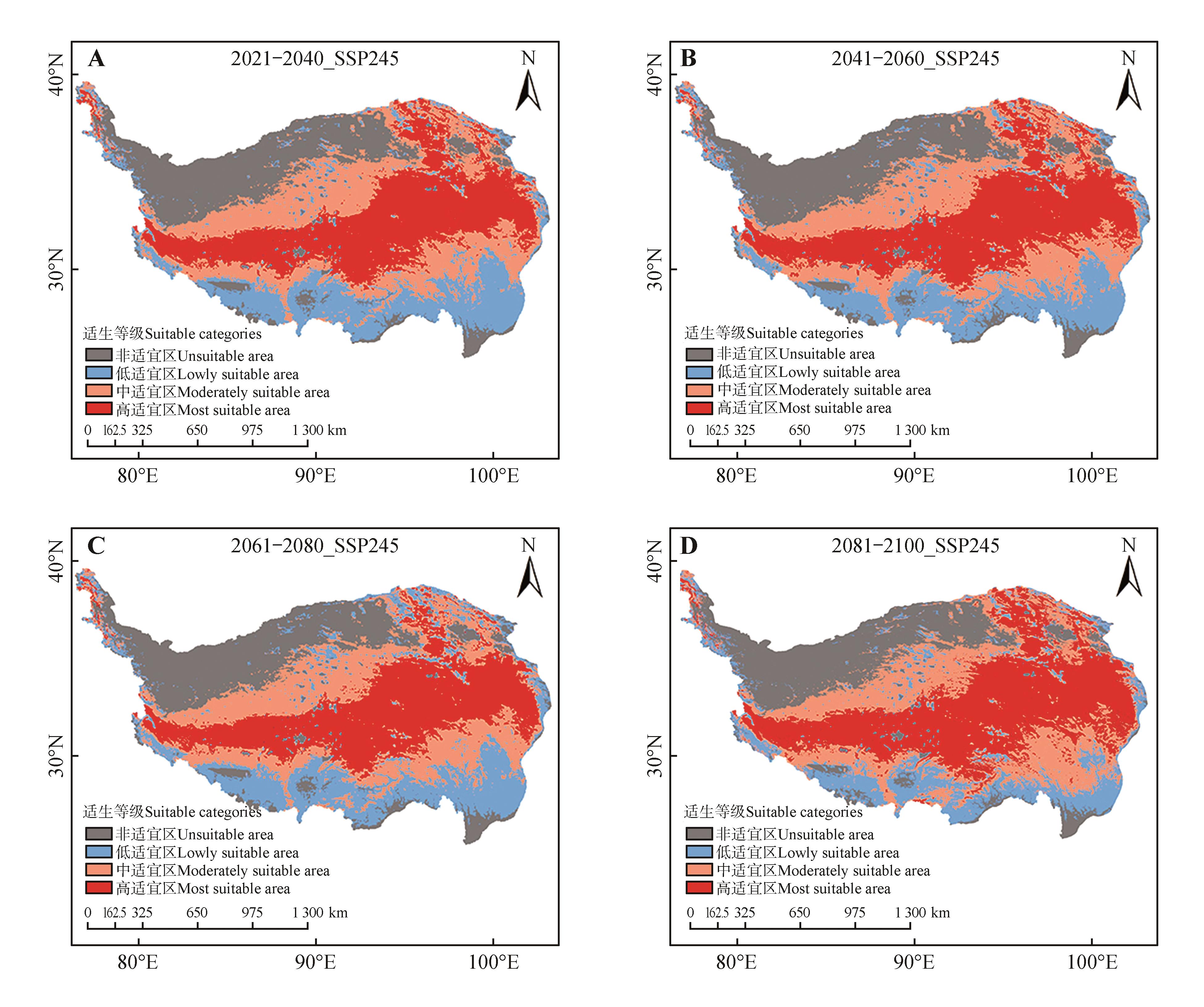
为探究唐古特红景天(Rhodiola tangutica)在青藏高原的潜在适宜分布及其生态适应性,基于唐古特红景天青藏高原38个分布位点以及当前和未来5个时期7个环境因子,利用MaxEnt模型构建唐古特红景天分布与环境因子的关系模型,模拟和验证当前时期1970—2000年与SSP245情景模式下未来4个时期(2030s、2050s、2070s和2090s)的潜在地理分布格局。结果表明:(1)海拔(Alt)和最干月份降水量(Bio14)是影响唐古特红景天地理分布格局的最主要生态因子,贡献率分别为89.3%和4.9%。(2)当前气候背景下,唐古特红景天在青藏高原地区的适宜分布区总面积为195.21×10⁴ km2,主要位于青海南部和东北部、四川西北部及西藏中部等。(3)与当前时期相比,未来4个时期唐古特红景天的适宜分布区总面积变化不太明显,但高适宜区面积却有所增加,呈现出向青藏高原中部集中分布的趋势。
中图分类号:
李小莉, 苏旭, 王东, 刘玉萍, 陈金元, 孙成林. 气候变化背景下青藏高原特有种唐古特红景天的地理分布格局预测[J]. 植物研究, 2024, 44(2): 168-179.
Xiaoli LI, Xu SU, Dong WANG, Yuping LIU, Jinyuan CHEN, Chenglin SUN. Prediction of the Geographical Distribution Pattern of Rhodiola tangutica(Crassulaceae) under the Background of Climate Change, an Endemic Species from the Qinghai-Tibet Plateau[J]. Bulletin of Botanical Research, 2024, 44(2): 168-179.
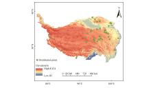
图1
唐古特红景天分布位点
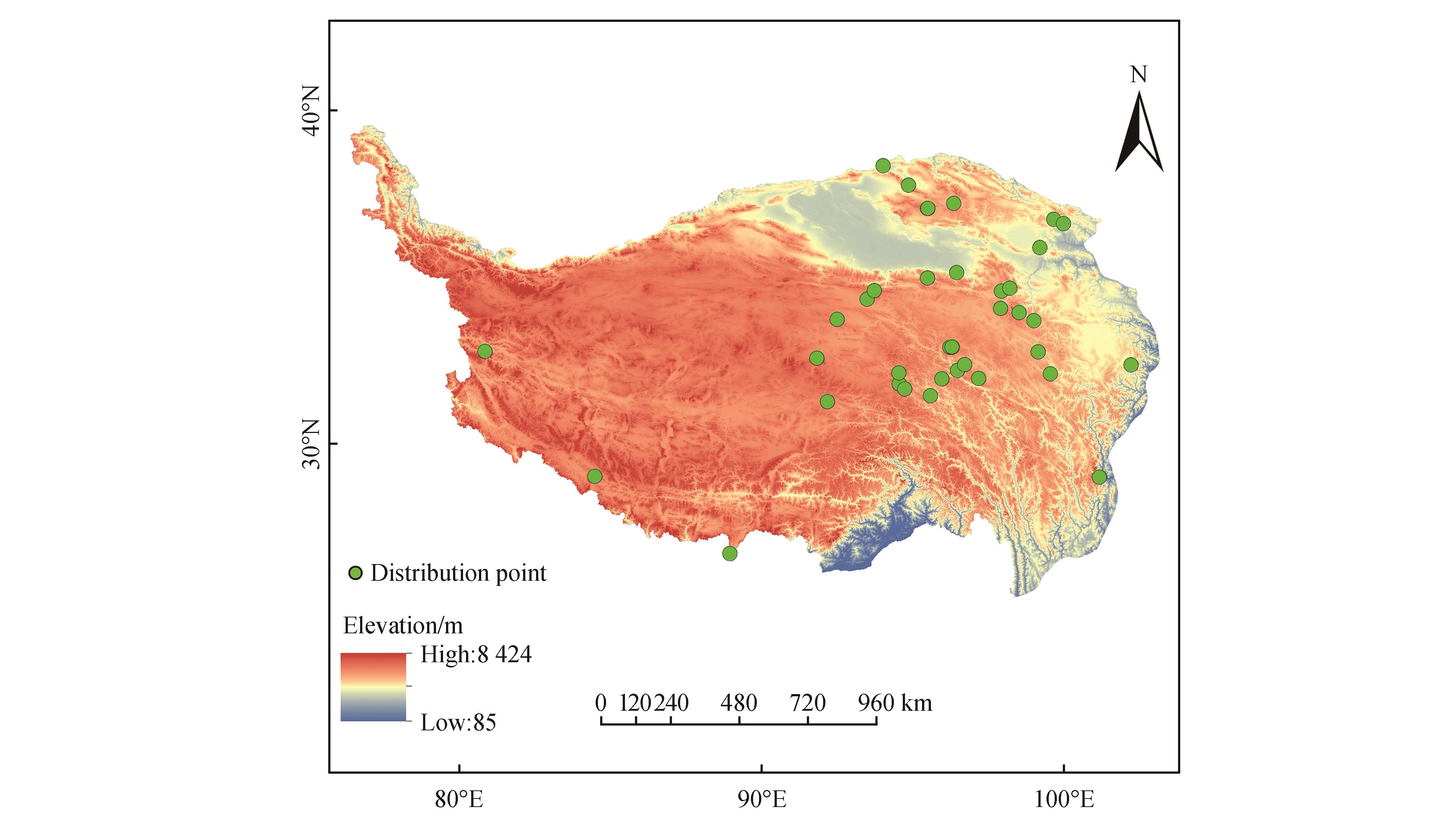
表1
生态因子对MaxEnt模型构建的贡献率
气候因子 Climate factor | 描述 Description | 贡献百分比 Contribution percent/% | 排列重要性 Permutation importance |
|---|---|---|---|
| Alt | 海拔Altitude | 89.3 | 73.5 |
| Bio14 | 最干月份降水量 Precipitation of Driest Month | 4.9 | 16.1 |
| Slope | 坡度Slope | 2.8 | 5.7 |
| Aspect | 坡向Aspect | 1.2 | 0.8 |
| Bio3 | 等温性Isothermality | 1.0 | 2.2 |
| Bio7 | 年温变化范围 Temperature Annual Range | 0.4 | 1.3 |
| Bio19 | 最冷季度降水量 Precipitation of Coldest Quarter | 0.4 | 0.4 |
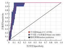
图2
受试者工作特征曲线


图3
主要环境因子的刀切法评价

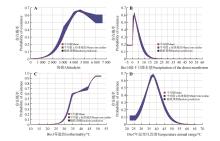
图4
主要生态因子的响应曲线


图5
当代气候背景下唐古特红景天的潜在适宜区分布
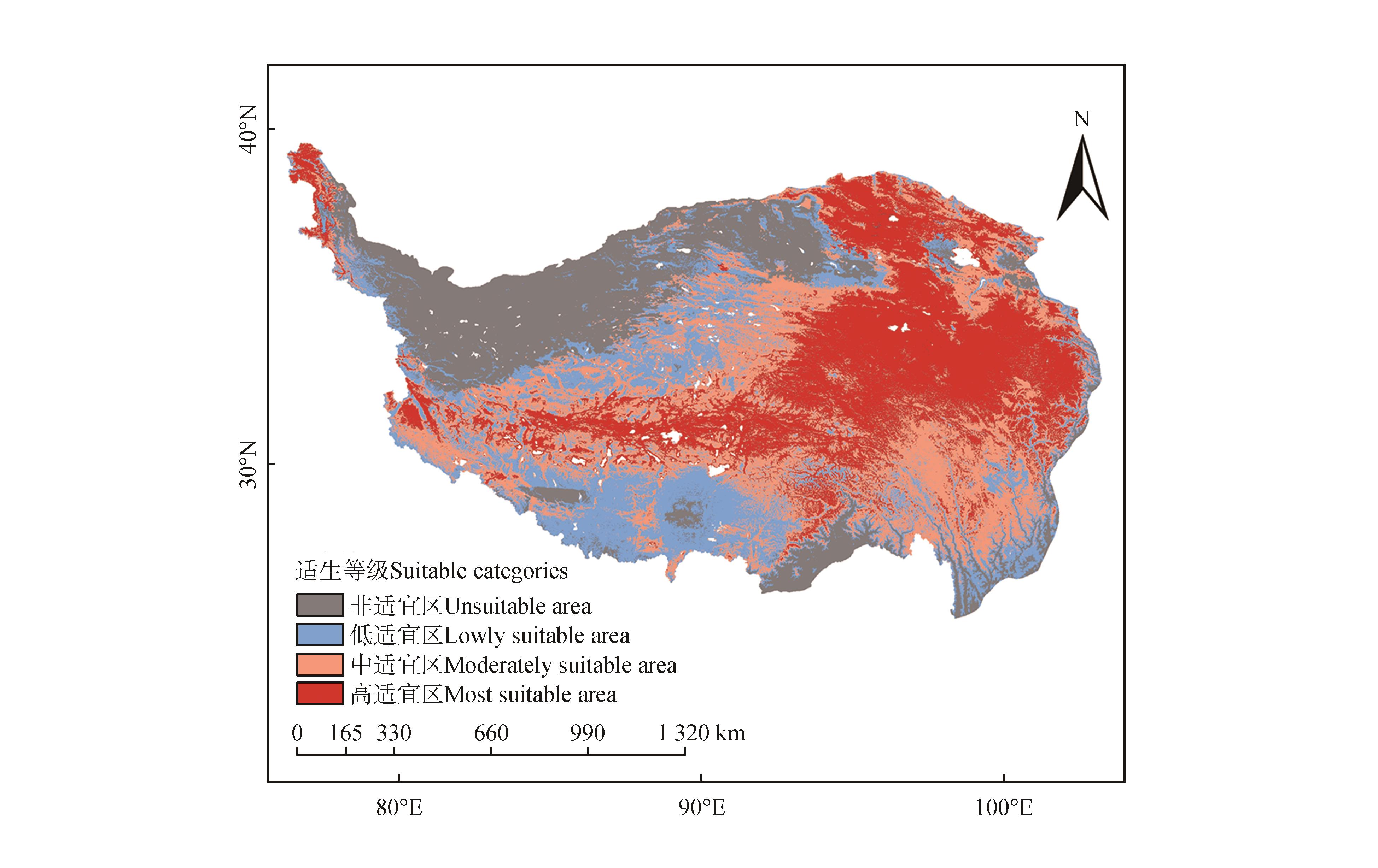
表2
唐古特红景天潜在适宜区面积变化
预测时段 Prediction period | 适宜区面积Suitable area/104 km2 | |||
|---|---|---|---|---|
非适宜区 Unsuitable area | 低适宜区 Low suitable area | 中适宜区 Moderately suitable area | 高适宜区 Highly suitable area | |
| 1970—2000年 | 54.79 | 51.14 | 79.33 | 64.74 |
| 2021—2040年 | 58.26 | 46.19 | 75.56 | 70.00 |
| 2041—2060年 | 58.84 | 43.96 | 75.85 | 71.35 |
| 2061—2080年 | 59.78 | 49.28 | 74.01 | 66.93 |
| 2081—2100年 | 57.32 | 36.32 | 75.87 | 80.49 |
图6
未来气候背景下唐古特红景天潜在适宜区分布
| 1 | 李京梅,张慧敏,王娜.生物多样性产品价值实现的路径与制度安排:国外生物多样性银行经验借鉴与启示[J].生态学报,2023,43(1):198-207. |
| LI J M, ZHANG H M, WANG N.Paths and institutional arrangements for the value realization of biodiversity products:experiences and inspirations of foreign bio-banking[J].Acta Ecologica Sinica,2023,43(1):198-207. | |
| 2 | ROMÁN-PALACIOS C, WIENS J J.Recent responses to climate change reveal the drivers of species extinction and survival[J].Proceedings of the National Academy of Sciences of the United States of America,2020,117(8):4211-4217. |
| 3 | 黄睿智,于涛,赵辉,等.气候变化背景下濒危植物梓叶槭在中国适生分布区预测[J].北京林业大学学报,2021,43(5):33-43. |
| HUANG R Z, YU T, ZHAO H,et al.Prediction of suitable distribution area of the endangered plant Acer catalpifolium under the background of climate change in China[J].Journal of Beijing Forestry University,2021,43(5):33-43. | |
| 4 | 葛颂.什么决定了物种的多样性?[J].科学通报,2017,62(19):2033-2041. |
| GE S.What determines species diversity?[J].Chinese Science Bulletin,2017,62(19):2033-2041. | |
| 5 | MATÍAS L, LINARES J C, SÁNCHEZ-MIRANDA Á,et al.Contrasting growth forecasts across the geographical range of Scots pine due to altitudinal and latitudinal differences in climatic sensitivity[J].Global Change Biology,2017,23(10):4106-4116. |
| 6 | LIU J, MÖLLER M, PROVAN J,et al.Geological and ecological factors drive cryptic speciation of yews in a Biodiversity hotspot[J].New Phytologist,2013,199(4):1093-1108. |
| 7 | 乔慧捷,胡军华,黄继红.生态位模型的理论基础、发展方向与挑战[J].中国科学:生命科学,2013,43(11):915-927. |
| QIAO H J, HU J H, HUANG J H.Theoretical basis,future directions,and challenges for ecological niche models[J].Scientia Sinica(Vitae),2013,43(11):915-927. | |
| 8 | 李芳菲,李丽,吴巩胜,等.基于最大熵模型的青海祁连山雪豹(Panthera uncia)生境适宜性评价[J].生态学报,2023,43(6):2202-2209. |
| LI F F, LI L, WU G S,et al.Habitat suitability assessment of Panthera uncia in Qilian Mountains of Qinghai based on MAXENT modeling[J].Acta Ecologica Sinica,2023,43(6):2202-2209. | |
| 9 | 唐杨欣,皮杰,刘新华,等.基于最大熵模型预测气候变化下河蚬在中国的潜在分布[J].生态学报,2023,43(10):4250-4259. |
| TANG Y X, PI J, LIU X H,et al.Predicting potential distribution of Corbicula fluminea under climate change scenarios using MaxEnt model[J].Acta Ecologica Sinica,2023,43(10):4250-4259. | |
| 10 | 雷乔期,王钰,窦家聪,等.基于MaxEnt模型山东省丹参药材适宜生产区划研究[J].北方园艺,2023(8):141-149. |
| LEI Q Q, WANG Y, DOU J C,et al.Research on the Regionalization of Salvia miltiorrhiza production suitability distribution based on MaxEnt model[J].Northern Horticulture,2023(8):141-149. | |
| 11 | 欧阳泽怡,李志辉,欧阳硕龙,等.基于Maxent和ArcGIS的赤皮青冈在中国的潜在适生区预测[J].中南林业科技大学学报,2023,43(2):19-26. |
| OUYANG Z Y, LI Z H, OUYANG S L,et al.Prediction of the potential distribution of Cyclobalanopsis gilva in China based on the Maxent and ArcGIS model[J].Journal of Central South University of Forestry & Technology,2023,43(2):19-26. | |
| 12 | PHILLIPS S J, DUDÍK M.Modeling of species distributions with Maxent:new extensions and a comprehensive evaluation[J].Ecography,2008,31(2):161-175. |
| 13 | 段义忠,鱼慧,王海涛,等.孑遗濒危植物四合木(Tetraena mongolica)的地理分布与潜在适生区预测[J].植物科学学报,2019,37(3):337-347. |
| DUAN Y Z, YU H, WANG H T,et al.Geographical distribution and prediction of potentially suitable regions of endangered relict plant Tetraena mongolica [J].Plant Science Journal,2019,37(3):337-347. | |
| 14 | 唐中海,罗华林,王建华,等.基于GIS和Maxent模型的白唇鹿(Cervus albirostris)潜在适宜生境及保护GAP分析[J].生态学报,2022,42(22):9394-9403. |
| TANG Z H, LUO H L, WANG J H,et al.Potential suitable habitat and protection gap analysis of white-lipped deer (Cervus albirostris) based on GIS and Maxent model[J].Acta Ecologica Sinica,2022,42(22):9394-9403. | |
| 15 | 左一帆,何宇凡,王璐,等.东亚地区羊肚菌属物种响应气候变化的地理分布格局变迁[J].应用生态学报,2023,34(3):777-786. |
| ZUO Y F, HE Y F, WANG L,et al.Change of geographic distributions of the genus Morchella species responding to climate oscillations in East Asia[J].Chinese Journal of Applied Ecology,2023,34(3):777-786. | |
| 16 | 李梓豪,李卓凡,洪光宇,等.气候变化背景下基于MaxEnt模型的蒙古莸潜在适生区预测[J].西北植物学报,2022,42(7):1232-1238. |
| LI Z H, LI Z F, HONG G Y,et al.Prediction of potential distribution of Caryopteris mongholica based on MaxEnt model in climate change context[J].Acta Botanica Boreali-Occidentalia Sinica,2022,42(7):1232-1238. | |
| 17 | 朱满乐,韦宝婧,胡希军,等.基于MaxEnt模型的濒危植物丹霞梧桐潜在适生区预测[J].生态科学,2022,41(5):55-62. |
| ZHU M L, WEI B J, HU X J,et al.Assessment of potential distribution for endangered plant Firmiana danxiaensis based on MaxEnt modeling[J].Ecological Science,2022,41(5):55-62. | |
| 18 | 李宁宁,张爱平,张林,等.气候变化下青藏高原两种云杉植物的潜在适生区预测[J].植物研究,2019,39(3):395-406. |
| LI N N, ZHANG A P, ZHANG L,et al.Predicting potential distribution of two species of spruce in Qinghai-Tibet Plateau under climate change[J].Bulletin of Botanical Research,2019,39(3):395-406. | |
| 19 | 王宏鹏,成璐路,滕彦娇,等.西藏大花红景天RcUDPGTs基因克隆与表达分析[J].药学学报,2021,56(7):2015-2024. |
| WANG H P, CHENG L L, TENG Y J,et al.Cloning and expression analysis of RcUDPGTs genes in Tibetan Rhodiola crenulata [J].Acta Pharmaceutica Sinica,2021,56(7):2015-2024. | |
| 20 | 吕秀梅,李艳,范刚,等.藏药红景天及其常用近缘品种研究进展[J].时珍国医国药,2016,27(7):1698-1701. |
| LÜ X M, LI Y, FAN G,et al.Advances in studies of Tibetan herbs Rhodiola and its relative species[J].Lishizhen Medicine and Materia Medica Research,2016,27(7):1698-1701. | |
| 21 | 陈金元,杜维波,苏旭.青海省国家重点保护野生植物名录:基于国家重点保护野生植物名录(2021版)[J].草业学报,2022,31(9):1-12. |
| CHEN J Y, DU W B, SU X.A taxonomic inventory of national key protected wild plants in Qinghai Province,based on the national checklist of key protected wild plants (2021)[J].Acta Prataculturae Sinica,2022,31(9):1-12. | |
| 22 | 雷淑芸,高庆波,付鹏程,等.基于Solexa高通量测序的唐古特红景天(Rhodiola algida)微卫星信息分析[J].植物研究,2014,34(6):829-834. |
| LEI S Y, GAO Q B, FU P C,et al.Analysis on microsatellites in Rhodiola algida based on Solexa sequencing[J].Bulletin of Botanical Research,2014,34(6):829-834. | |
| 23 | 黄政楠,杨占婷,于洋,等.基于ACE-AngⅡ-AT1R、ACE2-Ang(1-7)-MAS信号通路研究唐古特红景天活性部位抗大鼠高原缺氧性肺动脉高压的作用机制[J].中国高原医学与生物学杂志,2022,43(4):248-254. |
| HUANG Z N, YANG Z T, YU Y,et al.Study on the mechanism of active site of Rhodiola algida anti-high altitude pulmonary hypertension in rats based on ACE-AngⅡ-AT1R and ACE2-Ang(1-7)-MAS signaling pathways[J].Journal of Chinese High Altitude Medicine and Biology,2022,43(4):248-254. | |
| 24 | 续艳丽,朱仁愿,姬良亮,等.微波消解-电感耦合等离子体质谱法测定藏药唐古特红景天中27种元素[J].中国药事,2020,34(7):812-819. |
| XU Y L, ZHU R Y, JI L L,et al.Microwave digestion-ICP-MS for the determination of 27 elements in traditional Tibetan medicine Rhodiola tangutica [J].Chinese Pharmaceutical Affairs,2020,34(7):812-819. | |
| 25 | 王文婷,杨婷婷,金磊,等.未来气候变化下两种红景天植物的脆弱性[J].生物多样性,2021,29(12):1620-1628. |
| WANG W T, YANG T T, JIN L,et al.Vulnerability of two Rhodiola species under climate change in the future[J].Biodiversity Science,2021,29(12):1620-1628. | |
| 26 | 郑维列.西藏色季拉山长鞭红景天种群生态学特性研究[D].长沙:中南林业科技大学,2010. |
| ZHENG W L.The research on the ecological character of Longwhip Rhodiola’s population on Mt.Sergyela,Tibet[D].Changsha:Central South University of Forestry and Technology,2010. | |
| 27 | 国家林业和草原局,农业农村部.国家重点保护野生植物名录[EB/OL].(2021-09-08)[2023-03-28].. |
| National Forestry and Grassland Administration,Ministry of Agriculture and Rural Affairs.List of key protected wild plants in China[EB/OL].(2021-09-08)[2023-03-28].. | |
| 28 | 辛晓歌,吴统文,张洁,等.BCC模式及其开展的CMIP6试验介绍[J].气候变化研究进展,2019,15(5):533-539. |
| XIN X G, WU T W, ZHANG J,et al.Introduction of BCC models and its participation in CMIP6[J].Climate Change Research,2019,15(5):533-539. | |
| 29 | 赵懿.基于生态位模型预测不同气候情景下的杉木潜在适生区[D].长沙:中南林业科技大学,2022. |
| ZHAO Y.Predicting potential suitable habitats of Chinese fir under different climatic scenarios based on ecological niche models[D].Changsha:Central South University of Forestry and Technology,2022. | |
| 30 | 姬捷,郭旭东,杨莉萍,等.基于MaxEnt模型和ArcGIS的兰州百合潜在适宜分布区研究[J].中国中医药信息杂志,2023,30(5):1-4. |
| JI J, GUO X D, YANG L P,et al.Identification of potential distribution areas for Lilium davidii var.willmottiae by the MaxEnt model and ArcGIS[J].Chinese Journal of Information on Traditional Chinese Medicine,2023,30(5):1-4. | |
| 31 | 姚政宇,韩其飞,林彬.基于最大熵模型的新疆主要有毒杂草分布区预测[J].生态学报,2023,43(12):5096-5109. |
| YAO Z Y, HAN Q F, LIN B.Prediction of distribution area of main noxious and miscellaneous weeds in Xinjiang based on MaxEnt model[J].Acta Ecologica Sinica,2023,43(12):5096-5109. | |
| 32 | 王东升,赵伟,程蓓蓓,等.基于MaxEnt模型的中国山楂潜在适生区[J].林业科学,2022,58(7):43-50. |
| WANG D S, ZHAO W, CHENG B B,et al.Potential suitable areas of Crataegus pinnatifida in China based on MaxEnt modeling[J].Scientia Silvae Sinicae,2022,58(7):43-50. | |
| 33 | 国家青藏高原科学数据中心.青藏高原1∶100万行政边界数据(2017)[EB/OL].(2021-04-19)[2023-03-28].. |
| National Tibetan Plateau Science Data Center.Administrative boundary data of the Qinghai-Xizang Plateau at a scale of 1 ∶1,000,000(2017)[EB/OL].(2021-04-19)[2023-03-28].. | |
| 34 | 杨善云,安明态,刘锋,等.基于MaxEnt模型的贵州省楠木潜在适生区预测[J].广西植物,2023,43(5):846-857. |
| YANG S Y, AN M T, LIU F,et al.Prediction of potential suitable area of Phoebe zhennan in Guizhou Province based on MaxEnt model[J].Guihaia,2023,43(5):846-857. | |
| 35 | 王运生,谢丙炎,万方浩,等.ROC曲线分析在评价入侵物种分布模型中的应用[J].生物多样性,2007,15(4):365-372. |
| WANG Y S, XIE B Y, WAN F H,et al.Application of ROC curve analysis in evaluating the performance of alien species’ potential distribution models[J].Biodiversity Science,2007,15(4):365-372. | |
| 36 | 陈凯扬,王博,陈晨,等.祁连山特有濒危植物穴丝荠分布预测及其重要影响因子分析[J].西北植物学报,2022,42(11):1954-1961. |
| CHEN K Y, WANG B, CHEN C,et al.Distribution prediction and influential factors analysis of Coelonema draboides,an endemic and endangered plant in Qilian mountains[J].Acta Botanica Boreali-Occidentalia Sinica,2022,42(11):1954-1961. | |
| 37 | 青海植物志编辑委员会.青海植物志:第2卷[M].西宁:青海人民出版社,1999:155. |
| Editorial committee of Qinghai Flora.Flora of Qinghai:Vol.2[M].Xining:Qinghai People’s Publishing House,1999:155. | |
| 38 | 徐智玮,贾守宁,李亚伟,等.红景天属药用植物资源调查及保护利用研究[J].中国现代中药,2019,21(10):1348-1353. |
| XU Z W, JIA S N, LI Y W,et al.Investigation and conservation of medicinal plant resources of Rhodiola L.[J].Modern Chinese Medicine,2019,21(10):1348-1353. | |
| 39 | 郭斌,王珊,陈超,等.气候变化背景下川西北高原多年生垂穗披碱草种植适生区分布预测[J].草地学报,2019,27(6):1596-1606. |
| GUO B, WANG S, CHEN C,et al.Distribution prediction of suitable growth area of Perennial Elymus nutans in the northwest plateau of sichuan province under climate change[J].Acta Agrestia Sinica,2019,27(6):1596-1606. | |
| 40 | 杨烨,刘晓龙,陆祥,等.基于MaxEnt和ArcGIS的中国皂荚生态适宜性区划研究[J].时珍国医国药,2022,33(5):1201-1204. |
| YANG Y, LIU X L, LU X,et al.Ecological suitability regionalization of Gleditsia sinensis Lam. in China based on MaxEnt and ArcGIS[J].Lishizhen Medicine and Materia Medica Research,2022,33(5):1201-1204. | |
| 41 | 钱天陆,秦淑洁,吴朝宁,等.基于MaxEnt模型的人类干扰对滇金丝猴潜在分布的影响[J].兽类学报,2022,42(4):349-361. |
| QIAN T L, QIN S J, WU Z N,et al.Impacts of human interference on the potential distribution of Yunnan snub-nosed monkeys by MaxEnt model[J].Acta Theriologica Sinica,2022,42(4):349-361. | |
| 42 | 曹倩,高庆波,郭万军,等.基于MaxEnt模拟人类活动与环境因子对青藏高原特有植物祁连獐牙菜潜在分布的影响[J].植物科学学报,2021,39(1):22-31. |
| CAO Q, GAO Q B, GUO W J,et al.Impacts of human activities and environmental factors on potential distribution of Swertia przewalskii Pissjauk.,an endemic plant in Qing-Tibetan Plateau,using MaxEnt[J].Plant Science Journal,2021,39(1):22-31. | |
| 43 | 姜颖倩,王霞,贾秀秀,等.气候变化下矩镰荚苜蓿的地理分布格局及潜在适生区预测[J].西北植物学报,2022,42(9):1611-1620. |
| JIANG Y Q, WANG X, JIA X X,et al.Geographical distribution pattern and prediction of potential suitable areas of Medicago archiducis-nicolai under climate change[J].Acta Botanica Boreali-Occidentalia Sinica,2022,42(9):1611-1620. | |
| 44 | 赵文龙,陈红刚,袁永亚,等.气候变化对藏药独一味适生区分布格局的影响[J].草地学报,2021,29(5):956-964. |
| ZHAO W L, CHEN H G, YUAN Y Y,et al.The impact of climate change on the distribution pattern of the suitable growing region for Tibetan medicine Lamiophlomis rotata [J].Acta Agrestia Sinica,2021,29(5):956-964. | |
| 45 | 张春雨,刘爱利,吕嫣冉,等.基于CMIP6青藏高原腹地气候模拟评估及时空分析[J].高原气象,2023,42(5):1144-1159. |
| ZHANG C Y, LIU A L, LÜ Y R,et al.Spatial-temporal analysis and assessment of CMIP6 based climate simulation over the Qinghai-Xizang(Tibet)Plateau’s Hinterland[J].Plateau Meteorology,2023,42(5):1144-1159. | |
| 46 | 赵晓冏,巩娟霄,赵莎莎,等.样本量及其空间分布对物种分布模型的影响[J].兰州大学学报(自然科学版),2018,54(2):208-215. |
| ZHAO X J, GONG J X, ZHAO S S,et al.Impact of sample size and spatial distribution on species distribution model[J].Journal of Lanzhou University (Natural Sciences),2018,54(2):208-215. | |
| 47 | 樊信,盘金文,何嵩涛.气候变化背景下基于MaxEnt模型的刺梨潜在适生区分布预测[J].西北植物学报,2021,41(1):159-167. |
| FAN X, PAN J W, HE S T.Prediction of the potential distribution of Rosa roxburghii under the background of climate change Based on MaxEnt Model[J].Acta Botanica Boreali-Occidentalia Sinica,2021,41(1):159-167. | |
| 48 | 陈禹光,乐新贵,陈宇涵,等.基于MaxEnt模型预测气候变化下杉木在中国的潜在地理分布[J].应用生态学报,2022,33(5):1207-1214. |
| CHEN Y G, LE X G, CHEN Y H,et al.Identification of the potential distribution area of Cunninghamia lanceolata in China under climate change based on the MaxEnt model[J].Chinese Journal of Applied Ecology,2022,33(5):1207-1214. | |
| 49 | 张华,赵浩翔,徐存刚.气候变化背景下孑遗植物桫椤在中国的潜在地理分布[J].生态学杂志,2021,40(4):968-979. |
| ZANG H, ZHAO H X, XU C G.The potential geographical distribution of Alsophila spinulosain under climate change in China[J].Chinese Journal of Ecology,2021,40(4):968-979. | |
| 50 | 李晖,于顺利,央金卓嘎.西藏红景天植物的生态分布调查与资源的合理保护[J].资源开发与市场,2011,27(6):535-537. |
| LI H, YU S L, YANGJIN Z G.Investigation on ecological distribution of Rhodiola L. in xizang and its reasonable protection[J].Resource Development & Market,2011,27(6):535-537. | |
| 51 | 陈海娟.青海红景天属药用植物资源研究[D].沈阳:沈阳药科大学,2009. |
| CHEN H J.Research on medicinal plant resources of the Rhodiola Genus in Qinghai[D].Shenyang:Shenyang Pharmaceutical University,2009. |
| [1] | 贺晓慧, 高健, 朱丽, 郝瑞敏, 黄磊, 朱晋, 程莉, 周洁. 蒙古扁桃潜在地理分布对气候变化的响应[J]. 植物研究, 2024, 44(2): 180-191. |
| [2] | 杨倩, 袁园, 苏旭, 刘玉萍, 王东, 李小莉, 孙成林, 杨萍. 气候变化背景下糙果紫堇在中国适宜分布区的预测[J]. 植物研究, 2024, 44(1): 17-26. |
| [3] | 唐兴港, 袁颖丹, 张金池. 气候变化对杉木适生区和生态位的影响[J]. 植物研究, 2022, 42(1): 151-160. |
| [4] | 李宁宁, 张爱平, 张林, 王克清, 罗红燕, 潘开文. 气候变化下青藏高原两种云杉植物的潜在适生区预测[J]. 植物研究, 2019, 39(3): 395-406. |
| [5] | 刘然, 王春晶, 何健, 张志翔. 气候变化背景下中国冷杉属植物地理分布模拟分析[J]. 植物研究, 2018, 38(1): 37-46. |
| [6] | 雷淑芸1,2;高庆波1;付鹏程1;杨慧玲1*;陈世龙1;张发起1,3. 基于Solexa高通量测序的唐古特红景天(Rhodiola algida)微卫星信息分析[J]. 植物研究, 2014, 34(6): 829-834. |
| [7] | 王娟娟;曹博;白成科*;张琳琳;车乐. 基于Maxent和ArcGIS预测川贝母潜在分布及适宜性评价[J]. 植物研究, 2014, 34(5): 642-649. |
| [8] | 袁博;白红英*;章杰;马新萍. 秦岭山地植被净初级生产力及对气候变化的响应[J]. 植物研究, 2013, 33(2): 225-231. |
| [9] | 姜乃准, 段文标. 黑龙江省未来气候生态与森林的作用研究[J]. 植物研究, 1996, 16(2): 242-245. |
| 阅读次数 | ||||||
|
全文 |
|
|||||
|
摘要 |
|
|||||